Last verified
Colorado water rights map viewer, step by step
Colorado's water rights map is the free DWR Map Viewer, listed on the CDSS map viewers page. It puts every decreed structure in the state on an interactive map, ditches, wells, reservoirs and stream gauges, and each feature links through to the decree records behind it. DWR Map Viewer
This walkthrough finds the water features near a parcel and gets you to the WDID you need for everything else on this site. Budget about ten minutes.
What you will need
- The parcel's address, or its section-township-range, or roughly where it is on a map. Any of the three is enough.
- A desktop browser. The viewer works on a phone but the layer controls are painful.
- Nothing else. No account, no fee.
1Open the DWR Map Viewer
Go to the DWR Map Viewer. It is the all-inclusive viewer, with over 170 layers of DWR and Colorado Water Conservation Board data. It opens on a statewide map with a set of layers already switched on.
Give it a moment. It is a full GIS application, not a web page, and it loads like one.
2Navigate to the parcel
Use the search box to zoom to an address, a place name, or a section-township-range. If you only know the area, zoom manually — the county and section boundaries appear as you go in.
Zoom in further than feels necessary. Structures are dense along ditches, and at county scale the symbols overlap into meaninglessness.
3Turn on the layers you actually want
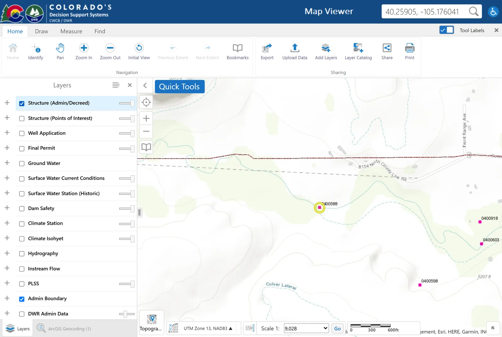
The default layers are a starting point, not the answer. Open the layer list and make sure these are on:
- Structures — ditches, reservoirs, wells and headgates, which is what a water right physically is.
- Water Districts and Water Divisions — so you know which division governs the parcel, and therefore which water court.
- Wells — permitted wells, including exempt ones.
- Streams — because the source name on a decree has to match a real watercourse.
Anything missing can be added from the Layer Catalog, which holds the full 170-plus.
4Click a structure and read the pop-up
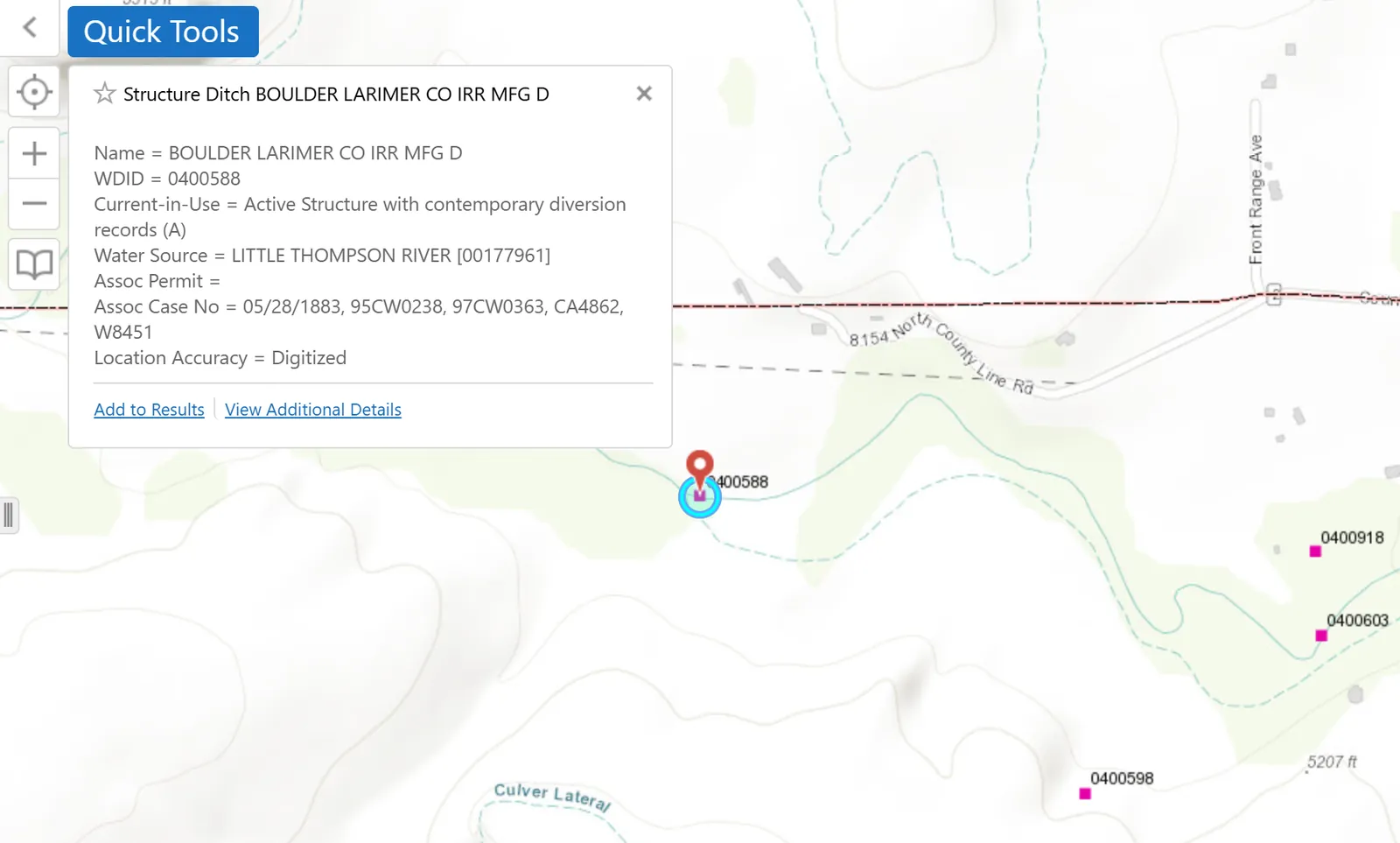
Click any structure symbol near the parcel. The pop-up gives you the structure name, its type, and — the part that matters — its WDID, the seven-digit identifier the state uses for everything. The first two digits are the water district.
Write the WDID down. It is the key to every other record, and searching by name instead will waste your afternoon: structure names in the records are abbreviated in ways nobody would guess, like BOULDER LARIMER CO IRR MFG D.
5Follow the links out to the records
The pop-up carries links into DWR's structure and water rights tools. Those take you to the Structures tool and the Water Rights — Net Amounts tool, where the decreed amounts, priority dates and case numbers live.
You can also go straight to the net amounts tool and search the WDID directly, which is faster once you have it.
6Read what you found — carefully
For each record, four fields tell you most of the story: the appropriation date (seniority), the administration number (seniority as actually administered), whether the amount is absolute or conditional, and the decreed uses.
Reading a decree is the next tutorial in this sequence and goes through a real record field by field.
What the map does not tell you
This is the part most walkthroughs skip, and it is where people get hurt.
- Ownership. The map shows structures, not who owns the rights diverted through them. A ditch crossing a parcel usually carries other people's water.
- Whether the right is in priority. A senior-looking date means nothing without the call history on that reach — check the active calls tool and ask the division engineer's office.
- What attaches to a parcel. Water is severable from land in Colorado. The map cannot tell you whether the water that once served this ground was sold in 1998 — checking a property covers the deed and ditch company work that can.
- Ditch company shares. They do not appear as rights at all; the company holds the decree.
Where to go next
If you were looking for a well rather than a ditch, the DWR Well Permit Viewer is the purpose-built version of this map, and searching well permits covers the records behind it. Otherwise carry your WDID to reading a decree, or back to the lookup hub to see which database answers which question.
Common questions
Is there a map of Colorado water rights?
Yes, and it is free. The DWR Map Viewer shows structures, wells, streams, water districts and divisions across the state, and each feature links to the underlying decree records. No account is required.
What happened to AquaMap?
It has been retired. CDSS's own Map Viewers page states that AquaMap is gone and that its functionality is now available in the web-based map viewers, principally the DWR Map Viewer and the DWR Well Permit Viewer.
What is a WDID?
The Water District IDentifier — the seven-digit code DWR assigns to a structure such as a ditch, well or reservoir. The first two digits identify the water district and the remainder identify the structure. It is the fastest and most reliable way to search state water records.
Can I see who owns a water right on the map?
No. The map viewer shows structures and their decreed rights, not beneficial ownership. Ownership is established from recorded deeds, ditch company share books, and DWR ownership records, and a ditch crossing a property usually carries water belonging to others.